Dingle Way: Trail Info
Introduction
For the most part, this walking tour follows the official trail of the Dingle Way (Slí Chorca Dhuibhne in Gaelic), a 179km (112 mile) long National Waymarked Trail around the Dingle Peninsula in County Kerry. The official beginning and end of the circular route is Tralee, the capital of Kerry.
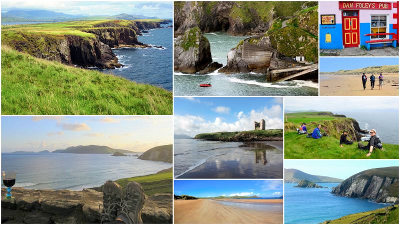
The diversity of landscapes is one of the reasons why the Dingle Way is such a popular trail. It never takes long before a turn in the path reveals a dramatic change of scenery. From walking in the foothills of Slieve Mish to crossing the shoulder of Mount Brandon, from the crashing waves of the Atlantic Ocean at Slea Head to the tranquil setting of pastoral farmland and golden beaches around Castlegregory. The Dingle Way invigorates the senses.
For those who love history and culture, some of the finest archaeological sites in Ireland can be encountered on the Dingle Way. Standing stones, ogham stones and a multitude of beehive huts are the most obvious structures to be spotted en route. Tralee and Dingle Town itself (An Daingean) are renowned cultural hubs of Ireland – it won’t take long to find some traditional music and Irish ‘craic’ in these locations.
Map
The Route
The Dingle Way is traditionally walked in a clockwise direction, starting out from Tralee and then heading along the northern slopes of the Slieve Mish Mountains. The route then branches south at the tiny village of Camp and crosses the peninsula towards Inch Beach. From there it moves on to the village of Annascaul, where you will find the famous South Pole Inn. The next stop is Dingle, the most westerly town in Europe, before the walk continues around the rugged westernmost point of Ireland at Slea Head.
The trail loops back to the north of the Dingle Peninsula via Dunquin and Ballyferriter, and then you will have the option to either make the climb over Masatiompan (at 650m, the highest point on the trail), or take a less strenuous alternative southern route over the shoulder of Mount Brandon into Cloghane. Next, there is a long, beautiful beach hike to Castlegregory, before heading back to Camp, and then retracing your steps to Tralee.
Terrain Overview
Most of the Dingle Way crosses low-lying land and looks up at mountains rather than down from them. The aggregate ascent over the route is approximately 2,900m, but, although there are some short steep ascents, there are almost no significant steep climbs. The exception to this is the traverse of Masatiompan (between Cuas and Cloghane), which sees the trail ascend to a height of 650 metres above sea level.
There is a wide variety of terrain covered by the Dingle Way and it consists mainly of quiet tarmac roads, mountain, field and cliff paths, and over 20km of good beach walking. Small roads, known locally in Ireland as 'boreens', make up a large part of the trail and help provide a quick walking pace.
Beaches make up a significant part of the Dingle Way, some of which provide an opportunity to take some weight off one's weary feet by taking a swim. The remainder of the walk goes through open farmland and mountainous moorland.
Elevation Profile (Click image to enlarge)
Terrain by Stages
Tralee – Camp: A gentle canal towpath leads away from Tralee. This is quickly followed by a rugged mountain path across the slopes of Slieve Mish.
Camp – Annascaul: This section consists of minor roads across the top of the peninsula, with a mixture of grassy tracks and paths.
Annascaul - Dingle: Here you will follow quiet country roads that run next to the coast. You will also traverse hillside paths through farmland.
Dingle – Dunquin: Leading out of Dingle town are quiet country roads. This is followed by a long beach walk, and the day ends with a mountain path to Slea Head.
Dunquin – Cuas: This section of the trail consists of a relatively gentle hike along minor coastal roads and quiet beaches. You will encounter some boggy patches towards the end of the hike.
Cuas – Cloghane (Option 1): This is a steep climb and descent along a lonely, rugged mountain path. It can be quite slippery when wet.
Cuas – Cloghane (Option 2): Alternatively, this is a long, relatively gradual ascent followed by more rapid descent along an old mountain road into Cloghane.
Cloghane – Castlegregory: This stretch of the route consists of a long beach walk interspersed with coastal paths and occasional road walking.
Castlegregory – Tralee: The final leg of the trail is a mixture of beach, road and mountain paths. There is a canal towpath from Blennerville into Tralee.


