Camino Frances: Trail Info
Introduction
The Camino Frances is one of the Camino de Santiago (“Way of St. James” in English) pilgrimage routes that lead to the shrine of the apostle St. James in the Cathedral of Santiago de Compostela. Together with Rome and Jerusalem, the Camino de Santiago was one of the three great Christian medieval pilgrimages. It is believed that St. James's remains were carried by boat from Jerusalem to northern Spain, where he was buried on the site of what is now Santiago de Compostela.
Every year, more and more people are discovering the magic of the Camino. The Camino Frances is the most popular of the many routes that lead to Santiago de Compostela. People of all ages and abilities decide to walk the Camino for various reasons, and many will say the experience changed their lives. Walking the Camino trail has now become increasingly popular, and is part of many people’s “bucket lists”.
In order to obtain their Compostela, the official Camino de Santiago Pilgrimage Certificate, pilgrims must complete at least the last 100km of the Camino. Our walking tours offer a choice of starting points, difficulties and route lengths on the last 160 km of the Camino Frances. Statistics from the Pilgrims Office state that 4% of walkers begin their Camino from O Cebreiro (160 km) while 25% of pilgrims start their journey to Santiago de Compostela in Sarria (114 km).
Camino Frances Map - O Cebreiro to Santiago de Compostela
The Route
The Camino Frances (or the French Way) begins on the French side of the Pyrenees, in Saint-Jean-Pied-de-Port. From there, it runs across the Pyrenees and continues through the north of Spain all the way to Santiago de Compostela, creating a walk that is, overall, almost 800km in length. The entire Camino Frances route can be completed within four to five weeks, passing through the major cities of Pamplona, Logrono, Burgos and Leon.
Our longest Camino walking tours start from the hamlet of O Cebreiro, one of the highest points on the Camino Frances. From here you will enjoy stunning mountain views as you descend along a mixture of tracks and footpaths to the village of Triacastela. There is a choice of routes from Triacastela to Sarria; the scenic northern route, through forests with woodland paths, or the southern route via the beautiful Samos Monastery.
Leaving Sarria, your walk to Portomarin will take you through many traditional Galician towns and villages on quiet rural roads and paths. The Camino then crosses the river Miño, passes through more hamlets and villages, and continues on country roads to Palas de Rei. On the next stage of the route you will pass through the market town of Melide and follow tracks and forest paths to Arzúa. The Camino Frances trail then continues through woodlands and villages, on country roads and forest tracks, to A Rua.
The final stage of the route will bring you to your destination, Santiago de Compostela, a UNESCO World Heritage site and home to many sights and attractions.
Terrain Overview
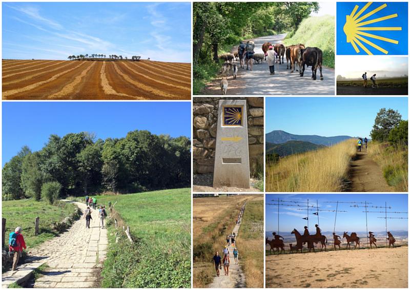
The terrain along the last 160km of the Camino Frances is well-suited for walking and includes woodland paths, tracks and lanes through pastures and villages, small rural roads and sandy footpaths that run parallel with roads.
The general feel of Galicia is often described as green, wooded and criss-crossed with old walled lanes. The Camino Frances in Galicia is often shaded, so it is cool and pleasant, even in the middle of the day during the summertime.
Unlike many modern long distance hiking routes, that might avoid large towns or villages, the ancient pilgrim routes like the Camino Frances pass through many settlements where shelter, food and refreshments are available. On some days on the Camino a pilgrim might pass 10 or 11 hamlets and villages.
The route of the Camino de Santiago through Galicia includes just a few steeper ascents and descents. There is one long but gentle descent before Triacastela and there are number of longer gradual climbs, particularly after Sarria and Portomarin. Total aggregate ascent over the last 160km of the Camino Frances is between 3,300m and 3,600m, depending on route choice. The highest point of the route is just outside O Cebreiro at 1,380m.
Elevation Profile (Click image to enlarge)
Terrain by Stages
O Cebreiro to Triacastela: A combination of forest, gravel & stony tracks, minor roads and stone-paved village streets; some minor climbs but the general direction is downhill, with 700m elevation difference from O Cebreiro to Triacastela
Triacastela to Sarria
San Xil Route: Minor roads soon followed by forest tracks and woodland paths that gently climb to Alto do Riocabo (910m); the final section of footpath beside the road into Sarria offers little shelter from sun and rain for the last 5km
Samos Route: Combination of minor roads, gravel paths, roads, forest tracks, woodland paths and a 3km section along main road; the final section of footpath beside the road into Sarria offers little shelter from sun and rain for the last 5km
Sarria to Portomarin: Woodland paths, tracks and very quiet country roads; some shorter climbs and a long and gentle descent into Portomarin with one optional steep descent just before the finish
Portomarin to Palas de Rei: Minor roads, forest tracks, woodland paths and gravel footpaths parallel to roads. One steep, long climb at the beginning
Palas de Rei to Melide: Forest tracks, woodland paths, country roads, stone-paved roads and gravel footpaths beside roads. Flat terrain overall
Melide to Arzua: Footpaths leaving Melide, gravel paths, forest tracks and paths, country roads, and footpath arriving into Arzua; two moderate but short climbs
Arzua to Rua: Forest path and tracks, country roads, gravel paths along roads; a little walking on tarmac; no notable climbs
Rua to Santiago: Forest tracks, country roads and gravel paths along roads; some tarmac and paved footpaths leading into Santiago; two short climbs - after O Amenal and up to Monte do Gozo


